Softwareentwicklung Heinz Lüdert
Version 4.0, now with USB interface and airspace!
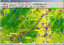
Airspace
PreFlight 4.0 knows the airspace and makes it visible on both generated maps and scanned maps.
To switch the airspace on and off, in the tool bar you'll find the new icon
 .
Airspaces you can add, delete or change. Creating an airspace is nearly as easy as to create a flight route.
.
Airspaces you can add, delete or change. Creating an airspace is nearly as easy as to create a flight route.
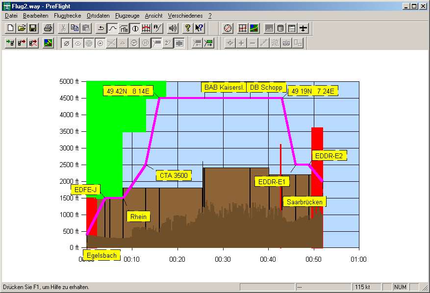
Vertical Profile
In the vertical profile you can see, whether your flight leads you above, through or below a specific airspace.
Garmin USB interface
PreFlight 4.0 supports your new Garmin USB GPS as well as older devices using the RS-232 interface.
Defining routes by user way points
PreFight 4.0 is able to create a GPS user way point for each way point of a flight route. Thus you can also
transfer routes to GPS devices which don't have an own airport database.
Reading the last route
Without knowing the name of the last GPS route, you can request to read the last route.
Tracks
While reading tracks, its also possible to directly request the last one.
Additionally, altitudes above 32000 feet can now be recorded and for each track point, the current distance
will be stored.
Reading and writing GPS user way points
PreFlight 4.0 reads user way points from your GPS device and stores them on your computer.
There you can edit the way points. Of course, you can also write the way points back to a GPS device.
Thus you will always have the required user way points available in your GPS.
Alternates
For each flight route, PreFlight 4.0 can hold two alternates. These alternates will affect the flight preparation
plan, the fuel consumption and the flight plan.
New scale function
If you have scanned different scaled maps of a specific region, you can use the symbol bar icons
 or
or  to switch between these maps. This simplifies the change from high to low resolution maps.
Export of map calibration
Use this function to copy a selection of your calibrated maps together with their calibration file into another directory.
(Later, this directory can be used to import the maps again.)
Elevation profiles (1 km)
Now calibrated elevation profiles can be imported and exported like scanned maps.
Additionally you can use SRTM elevation profiles. Compared with the profiles used up to now,
SRTM profiles offer a higher resolution.